


 29 / 48

January 3-16, 2018
-
Page 29
www.crej.comIn the late 1990s, Denver’s Central Platte V alley (CPV )
was beginning a renaissance as Riverfront Park,
Denver’s “ urban resort” . The newly developed 61‐acre
mixed‐use urban village gradually descended from
the city center to re‐engage the South Platte River
greenway. Completed in 2002, the centerpiece of the
urban resort is the three‐block extension of the 16th
Street pedestrian mall. Fifteen years later, this active
public space continues to anchor the Riverfront Park
master plan that was envisioned by DesignWorkshop,
East West Partners, Trillium Corporation and the City
andCountyof enver. orthepastthirty-fiveyears,the
original pedestrian mall designed by Pei Cobb Freed
and H annah/O lin has been Denver’s most important
public space serving as a transportation spine, a retail
destination and the organizing axis for downtown
Denver. H owever,themallterminatedatDenver U nion
Station until in 2002 the extension’s iconic Millennium
Bridge re‐established the pedestrian connection
over the Consolidated Main Line (CML) between
downtown and the South Platte River, ultimately
connecting to the cosmopolitan Lower H ighlands
neighborhood. The 16th Street 16th Street Pedestrian
Mall Extension honors the material qualities of the
original pedestrian mall while becoming the heart of
the burgeoning Riverfront Park urban community.
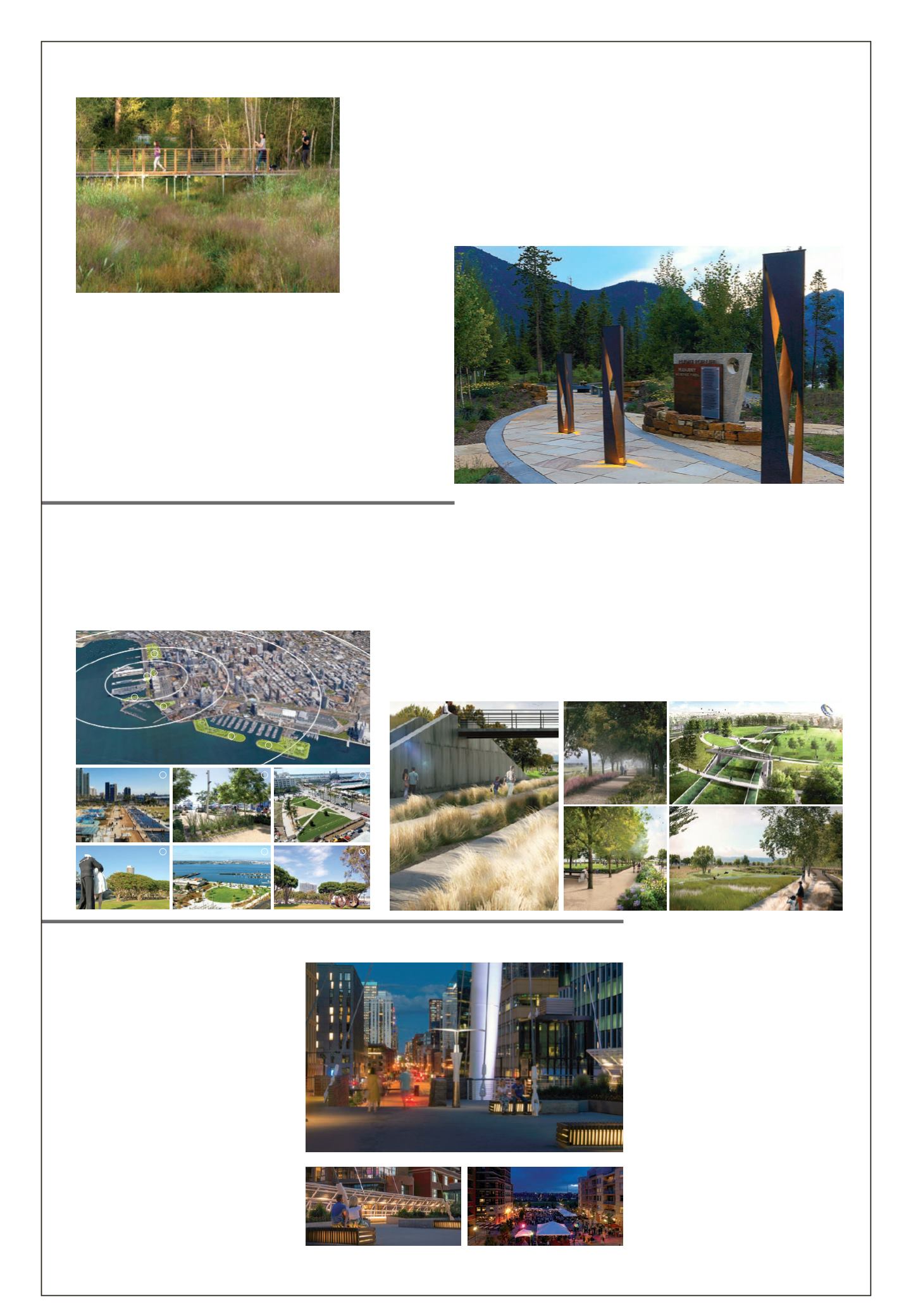
The Roaring Fork River bisects the mountain town of Basalt, creating
both opportunities and challenges for this Western Slope community.
A cohesive design team of Landscape Architects, Ecologists, and
Engineers collaborated to restore and realign the river and to provide
safe access for the community. The process included removal of
an outdated levee and the alteration of hydrological patterns to
address sedimentation and erosion. The ƪoodplain was adjusted
and wetland systems were expanded. Developable land was created
adjacent to the downtown core outside of the ƪoodplain and new
par spaces were created adjacent to the river within the ƪoodplain.
The project resulted in opportunities for people to interact with the
river and provided a vital, visual and physical connection to the river.
The Roaring Fork River is now better connected to the adjacent
downtown core, serving as an integral part of the community’s identity
for years to come. The restoration project is a model of community
stewardship allowing for human interaction and connection to a
riparian corridor that embodies a healthy and beautiful ecosystem.
St. Anthony’s Summit Medical Center, a Level III Trauma Center, sits at roughly 9,100 feet above sea level
in the mountains of Frisco, Colorado. The hospital is distinguished for having a Flight For Life Colorado
operation base on site, and works hand‐in‐hand to save the lives of critically injured people within a 120‐
mile radius. n uly ͛, ͚͙͘5, a tragic helicopter crash occurred during taeoff next to the paring lot, taing
the life of pilot and decoratedVeteran atric Mahany, while two ƪight nurses miraculously survived with
critical injuries.The Flight For Life Mahany H eroes Park recognizes these heroic victims, along with the 15
courageous bystanders who ran into the fire that day to help.The design of the par creates specific areas
to honor, celebrate, and reƪect the people and professionals who choose to put the lives of others above
their own on a daily basis. Adjacent to Forest Service lands along the Summit County Recreation Path and
hospital paring lot, the par is easily accessible to the community and hospital staff. Though the site is
small at approximately 0.2 acres, the overall emotional impact on visitors is truly monumental.The Flight
ForLifeMahany H eroesParkservesnotonlyasamemorialforthecherished lifeofPatrickMahany,butalso
as a healing ground for themany who were affected by such an unforgettable and heart-wrenching event.
The North Embarcadero is a highly active urban waterfront at the foot of
downtown San Diego, where the city meets the Bay. This valuable waterfront
district, owned by the Port of San Diego, is often referred to as the “ front porch”
of the city. It is home to many popular visitor attractions and museums, an
array of hotels and dining options, and the landing point of cruise operations
year-round. uilding upon the completion of the Civitas designed first phase
of the North Embarcadero, the waterfront is positioned to emerge as a world-
class destination that celebrates the character of San Diego and the Bay.
uilding upon the open space networ created south of nterstate ͘͟, the North Stapleton ars Master lan represents
the vision and goals of a new public par space. The North Stapleton ars Master lan is a synthesis of aesthetic,
programmatic and technical demands on 470‐acres of parkland. Focused on managing regional drainage needs within
the open space, the natural drainage ƪow is reversed to connect into the Sand Cree drainage. The location and
proportion of open space was designed as a framework to provide connectivity and amenity to proposed residential
and commercial neighborhoods. Design inspiration came from recognizing the tremendous opportunity to express
the relationship of pre and post‐settlement habitation of life on the prairie within the park experiences. The Sand H ill
Prairie ecosystem of Colorado’s Front Range forms the basis of the open space and the heart of the community.
North Stapleton’s open space plan illustrates an environmental networ that ties this new community together.
It
builds
on
Denver’s
rich
legacy
of
traditional
community
parks
and
recreational
facilities,
parkways
and
greenbelts
connecting
neighborhoods,
lakes
and
other
natural
features.
As the most expansive system of new parks introduced into the City and County of Denver Parks and
ecreation networ, the design team wored extensively with the development team, City Staff, and
future residents to establish a vision that fit with the lifestyle goals of the community, met the operational
and maintenance requirements of the City, and integrated into the expansive Denver Parks system.
Basalt River Restoration
| DHM Design |
B asalt, Colorado
F light f or Lif e Mahany Heroes Park
| Norris Design |
S um
m it County, F risco, Colorado
North Emb arcadero Nex t Plan
| Civitas |
S an Diego, Calif ornia
Stapelton North O pen Space Master Plan
| Civitas |
Denver, Colorado
A Modern Legacy
| DesignWorkshop |
Denver, Colorado
DESIGN
LANDMARK
A MODERN LEGACY: THE EVOLUTION OF THE 16TH STREET PEDESTRIAN MALL EXTENSI
Denver, Colorado
Project Significance
The 16th Street Pedestrian Mall Extension is a distinguished and memorable landscape architec
pleted 15 years ago that retains its original design intent and is the significant public space in t
community. The project is significant and award-worthy because it is the foundation of an imp
scape that feels both connected and distinct in its physical manifestation. The 16th Street Pede
sion provides the critical missing link over the train tracks to connect the city to the river and it
downtown Denver.
Services Provided:
Team Members:
Site Design
Todd Johnson- Principal-in-Charge
Chuck Ware - Proj
Landscape Architecture
Todd Wenskoski
Jeff McMenimen
Jamie Fogle
Jeremy Alden
Project Statement:
In the late 1990s, Denver’s Central Platte Valley (CPV) was beginning a renaissance as Riverfront Park, Denver’s
“urban resort”. The newly developed 61-acre mixed-use urban village gradually descended from the city cen¬¬ter
to re-engage the South Platte River greenway. Completed in 2002, the centerpiece of the urban resort is the
three-block extension of the 16th Street pedestrian mall. Fifteen years later, this active public space continues to
anchor the Riverfront Park master plan that was envisioned by Design Workshop, East West Partners, Trillium Cor-
poration and the City and County of Denver.
For the past thirty-five years, the original pedestrian mall designed by Pei Cobb Freed and Hannah/Olin has been
Denver’s most important public space serving as a transportation spine, a retail destination and the organizing
axis for downtown Denver. However, the mall terminated at Denver Union Station until in 2002 the extension’s
iconic Millennium Bridge re-established the pedestrian connection over the Consolidated Main Line (CML) be-
tween downtown and the South Platte River, ultimately connecting to the cosmopolitan Lower Highlands neigh-
A MODERN LEGACY: THE EVOLUTION OF THE 16TH STREET PEDESTRIAN MALL EXTENSION
Denver, Colorado
Project Significance
The 16th Street Pedestrian Mall Extension is a distinguished and memorable landscape architecture project com-
pleted 15 years ago that retains its original design intent and is the significant public space in the Riverfront Park
community. The project is significant and award-worthy because it is the foundation of an important cultural land-
scape that feels both connected and distinct in its physical manifestation. The 16th Street Pedestrian Mall Exten-
sion provides the critical missing link over the train tracks to connect the city to the river and it is a catalyst for
downtown Denver.
Services Provided:
Team Members:
Site Design
Todd Johnson- Principal-in-Charge
Chuck Ware - Project Manager
Landscape Architecture
Todd Wenskoski
Jeff McMenimen
Jamie Fogle
Jeremy Alden
Heath Mizer
Yu-Ju Liu
tement:
0s, Denver’s Central Platte Valley (CPV) was beginning a renaissance as Riverfro t Park, Denver’s
. The newly developed 61-acre mixed-use urban village gradually descended from the city cen¬¬ter
the South Platte River greenway. Completed in 2002, the centerpiece of the urban resort is the
tension of the 16th Street pedestrian mall. Fifteen years later, this active public space continues to
erfront Park master plan that was envisioned by Design Workshop, East West Partners, Trillium Cor-
the City and County of Denver.
irty-five years, the original pedestrian mall designed by Pei C bb Fr ed and Hannah/Olin has been
important public space serving as a transportation spine, a retail destination and the organizing
own Denver. However, the mall terminated at Denver Union Station until in 2002 the extension’s
ium Bridge re-established the pedestri n connection over the Co solidated Main Line (CML) be-
wn and the South Platte River, ltimately connecting to the cosmopolitan Lower Highla ds neigh-
16th Street 16th Street Pedestrian Mall Extension honors the material qualities of the original pedes-
le becoming the heart of the burgeoning Riverfront Park urban community.
A series of boardwalks connects the river and adjacent developed areas while maintaining and protecting the wetlands in between.
The illuminated steel pillars represent the three victims of the crash. At varying heights, they were designed
to represent wind movement and guide visitors into and through the park.
1
2
3
4
5
6
NORTH
EMBARCADERO
VISION
PLAN
2 0 1 7 A S L A C O L O R A D O D E S I G N A W A R D E N T R Y
The North Embarcadero is a highly active
urban waterfront at the foot of downtown
San Diego,where the city meets the Bay.
This valuable waterfront district,owned by
the Port of San Diego, is often referred to
as the“front porch”of the city. It is home
to many popular visitor attractions and
museums,an array of hotels and dining
options,and the landing point of cruise
operations year-round.
Building upon the principles and success
of previous planning and design efforts
(
PICTUREDABOVE
,) the NExt plan outlines
the potential open space design/
programming,circulation network,and
parking strategies for the completion of
the North Embarcadero.The plan outlines
a vision for the creation of a 21st Century
waterfront experience, that will provide
more meaning to more types of people,
resulting in a dynamic and engaging
waterfront experience for residents and
visitor alike.
0.25mi
0.5mi
1.0mi
1.5mi
1
2 3
4
5
6
6
1.CountyWaterfrontPark
2.NEVPPhase1
3.LaneFieldPark
4.TunaHarborPark
5.RuoccoPark
6.EmbarcaderoMarinaPark (North&South)
SanDiego
ConventionCenter
SanDiego
International
Airport
Little Italy
Maritime
Museum
Midway
Museum
Coronado
Ferry
Gaslamp
HortonPlaza
Children’sMuseum
CivicTheatre
PetcoPark
Balboa
Park
Seaport
Village
Marina
Park
N
PHASE 1
NEVP_Board_verion 3.indd 1
8/16/17 7:55PM
Building upon the open space network
created south of Interstate 70, theNorth
Stapleton ParksMaster Plan represents
the vision and goals of a new public
park space. TheNorth Stapleton Parks
Master Plan is a synthesis of aesthetic,
programmatic and technical demands
on 470-acres of parkland.Focused on
managing regional drainage needswithin
the open space, the natural drainage flow
is reversed to connect into the Sand
Creek drainage.
The location and proportion of open
spacewas designed as a framework to
provide connectivity and amenity to
proposed residential and commercial
neighborhoods.Design inspiration
came from recognizing the tremendous
opportunity to express the relationship of
pre and post-settlement habitation of life
on the prairiewithin the park experiences.
NORTH
STAPLETON
OPEN
SPACE
MASTER
PLAN
2 0 1 7 A S L A C O L O R A D O D E S I G N A W A R D E N T R Y
STAPLETON_Board.indd 1
8/16/17 1:27PM
Building upon the open space network
created south of Interstate 70, theNorth
Stapleton ParksMaster Plan represents
the vision and goals of a new public
park space. TheNorth Stapleton Parks
Master Plan is a synthesis of aesthetic,
programmatic and technical demands
on 470-acres of parkland.Focused on
managing regional drainage needswithin
the open space, the natural drainage flow
is reversed to connect into the Sand
Creek drainage.
The location and proportion of open
spacewas designed as a framework to
pr vide con ectivity and amenity to
proposed residential and commercial
neighborhoods.Design inspiration
came from recognizing the tremendous
opportunity to express the relationship of
pre and post-settlement habitation of life
on the prairiewithin the park experiences.
NORTH
STAPLETON
OPEN
SPACE
MASTER
PLAN
2 0 1 7 A S L A C O L O R A D O D E S I G N A W A R D E N T R Y
STAPLETON_Board.indd 1
8/16/17 1:27PM